Queensland floods: what do history and river hydrology tell us?
In April 2011 I wrote the opinion piece Queensland floods: information, history and knowledge to highlight how the January 2011 floods in South East Queensland had their historical precedents, in the hope of encouraging the better use of historical information in flood risk planning.
That eastern Australia has experienced devastating floods in January 2013, just two years after the horrors of January 2011, comes to me as no surprise. These floods are not extraordinary or unexpected events. Rather, they are a normal part of the considerable climatic variability experienced in eastern Australia.
Page 22 of this report discusses how this climatic variability leads to a cycle of decades-long wetter conditions followed by decades-long drier conditions:
South-eastern Australia experiences marked climatic cycles of wetter-than-average conditions (these are called Flood-Dominated Regimes, or FDRs) and drier-than-average conditions (these are called Drought-Dominated Regimes, or DDRs). FDRs and DDRs can last from 30 to 50 years.
These cycles are reflected in the Total Annual Flow graph below, which comes from page 19 of the same report. Because the drier-than-average or wetter-than-average conditions last for a few decades people become used to them, and come to incorrectly believe that the FDR or DDR they are in is ‘normal’ and how things will and should always be.
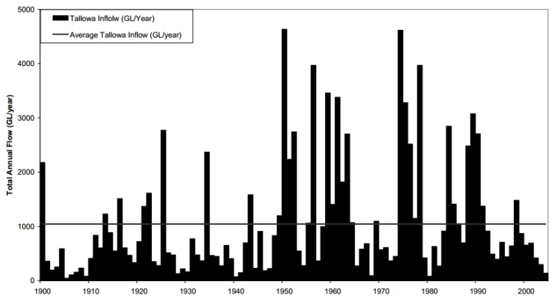
A cursory look at rainfall records for South East Queensland shows wetter-than-average conditions in the 1950s, 1960s and 1970s (which includes the devastating 1974 floods), and drier than average conditions in the 1980s, 1990s and 2000s. The 2011 floods were to me an alarm bell for the potential return of a Flood-Dominated-Regime (FDR) in South East Queensland.
As each part of eastern Australia experiences its own particular climatic circumstances the climatic variability of one area can’t simply be extrapolated to another. Every region, and indeed every river, needs to be studied and understood. This understanding will always be a work-in-progress as the knowledge base is continually improved through further research and analysis.
When will flood risk planning adequately reflect the realities of history and river hydrology? Hopefully before more lives are lost and more people have to suffer losing their homes, possessions and life memories. Some people have had to endure the losses from flooding twice in two years. Is this something that we want to keep happening to our fellow Australians?
And if we can’t adequately plan for historical climate variability, then what chance do we have of protecting life and property from more extreme and intense flood events into the future? The Australia and New Zealand chapter of the contribution of Working Group II to the Fourth Assessment Report of the Intergovernmental Panel on Climate Change (IPCC) alerts that:
The climate of the 21st century is virtually certain to be warmer, with changes in extreme events. Heatwaves and fires are virtually certain to increase in intensity and frequency [and] Floods, landslides, droughts and storm surges are very likely to become more frequent and intense.
The Bureau of Meteorology reports in a media release that the record-breaking heatwave that Australia has experienced this summer “is consistent with the trend of an increase in extreme heat events associated with climate change”, and we may well also already be experiencing more extreme flood events associated with climate change.
What is the solution? A good example is the Lockyer Valley Regional Council initiative to relocate flood-devastated residents to higher ground after the 2011 floods.
Postscript: See also my later RealKM Magazine articles also discussing climatic variability and climate change in eastern Australia:
- Critical Eye: Why those climate views can’t be given equal voice and hearing
- The vital knowledge missing from Australia’s bushfire crisis debates: Part 1 – What can climate history tell us?
Several related articles by other authors have also been published:
- Meet El Niño’s cranky uncle that could send global warming into hyperdrive
- Old floods show Brisbane’s next big wet might be closer than we think
- Droughts and flooding rains: it takes three oceans to explain Australia’s wild 21st-century weather
- California Megaflood: Lessons from a Forgotten Catastrophe
- Bushfire-ravaged towns should not be rebuilt, planning expert warns